Great Salt Flats (Salinas Grandes)
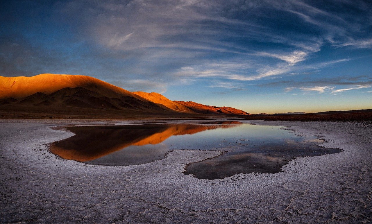
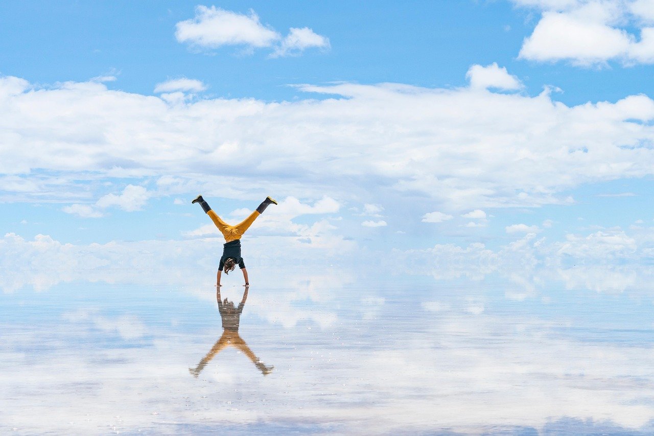
At 3,450 metres above sea level, the world becomes white and silent and impossibly bright. The Salinas Grandes stretch for over 212 square kilometres — a vast crust of salt so dazzling in the Andean sun that polarised sunglasses barely suffice. Standing in the middle of this ancient seabed, the horizons dissolve into sky, and the usual rules of distance and perspective stop working. A bottle placed ten metres away looks as though it is beside a mountain range. This is the optical illusion game that everyone who comes here cannot resist playing.
History of the Salinas Grandes
The Salinas Grandes occupy a high-altitude basin straddling the border of the Jujuy and Salta provinces of northwest Argentina. This ancient lake evaporated over millions of years, leaving behind a crystalline crust of sodium chloride between 20 and 60 centimetres thick, underlain by a brine layer. The region sits on the Puna, the high Andean plateau that extends from Argentina through Bolivia and into Chile — geologically related to the more famous Salar de Uyuni across the border, though smaller and less visited by mass tourism.
Indigenous Atacameño communities have harvested salt from the Salinas Grandes for centuries, and small-scale extraction continues today. Cooperatives from the villages of Tres Morros, Santuario de los Tres Pozos, and Pozo Bravo operate the extraction sites and small artisan stalls at the roadside, selling salt sculptures — llamas, condors, and cacti — carved from blocks of the mineral. Buying directly from these cooperatives is one of the most direct ways to support the communities that have stewarded this landscape for generations.
What to See and Do
The experience of visiting the Salinas Grandes is primarily one of visual wonder and perspective play. The salt crust is decorated with a network of hexagonal patterns — the result of the crystallisation process as water evaporates — and these geometric forms create extraordinary photographic compositions. The perspective trick photographs (placing small objects to appear gigantic against the infinite flat horizon) have become a visitor ritual, and the flat surface accommodates endless creativity.
Beyond photography, there are pools of brine-water pierced through the salt to show the mineral deposits below, and visitors can observe the salt extraction process in the working sections. The drive across the Cuesta de Lipán mountain pass leading down from the ravine to the salt flats is itself a highlight — a series of dramatic switchbacks revealing the entire Quebrada de Humahuaca below and the vast Puna ahead. Sunrise and sunset on the flats are extraordinary, when the sky turns pink and orange and the salt takes on impossible warmth.
The Journey Up: Cuesta de Lipán
The road from Purmamarca in the Quebrada de Humahuaca up to the Salinas Grandes via the Cuesta de Lipán is one of the great mountain drives in South America. The route climbs 1,800 metres in roughly 50 kilometres through a series of tight switchbacks, offering ever-widening views back down into the multicoloured ravine below. At the top, at around 4,170 metres, a small hamlet marks the transition from the deep canyon to the high Puna plateau — and suddenly the landscape opens into immensity.
This altitude is serious. Most visitors from sea level will feel the effects of the thin air — shortness of breath, mild headache, and fatigue are normal. Taking the journey slowly, drinking plenty of water, and having coca leaf tea or sweets before the drive reduces the impact. The road itself is paved and requires no special vehicle, though driving slowly on the mountain section is recommended. Some shared van services run daily from Purmamarca to the salt flats and can be a more relaxed option than self-driving.
Practical Information
- Tickets: Approx. USD 2 entry per person collected at the main access point
- Opening hours: Open daily, accessible at all hours; community stalls active roughly 08:00–17:00
- Best time to visit: May–October (dry season) for mirror-flat white surface and clear skies; January–March rainy season creates a partial water layer for mirror-effect reflections
- Duration: 1–2 hours at the flats; allow half a day from Purmamarca including the scenic drive
- Booking: No advance booking needed; shared vans from Purmamarca depart daily from around 08:00–10:00
Local Insights
What locals know that guidebooks don’t always tell you:
- Buy a salt carving directly from the indigenous cooperatives at the roadside — not from resellers in Salta or Jujuy. The price is better and the money reaches the community directly.
- Bring more water than you think you need. The combination of altitude, dry air, and high UV exposure dehydrates you faster than at sea level.
- There is a single basic toilet on site (historically a paid port-a-loo). Bring toilet paper as a precaution.
- For the classic perspective photos, a wide-angle lens works best. A second person and a handful of props (small figurines, a water bottle) are all you need.
- Come on weekdays if possible. On weekends and Argentine public holidays, the main photo spots become congested with tour groups by late morning.
Getting There
- By car: From Purmamarca, take RN 52 west — approx. 68 km, around 1 hour 15 min over the Cuesta de Lipán pass
- Shared vans: Depart daily from Purmamarca plaza from around 08:00 once they reach capacity (about 15 passengers); no fixed schedule
- Organised tours: Full-day tours from Salta city (approx. 3.5 hrs each way) or Jujuy city (2.5 hrs) available through local agencies
- Taxi/Remise: Private hire from Purmamarca is possible and convenient for small groups — negotiate a return price in advance
Frequently asked questions
Can I walk on the salt crust?
Yes, visitors are encouraged to walk on the surface — it is thick and solid in the dry season. In the wet season, the surface may be partially submerged in a shallow water layer, which creates the mirror effect but makes walking messier.
What should I bring?
Sunglasses (polarised if possible), high-SPF sunscreen, plenty of water, a hat, and a light layer for wind. The temperature on the Puna can drop sharply even in summer afternoons. Props for perspective photos are entirely optional but fun.
Is there anywhere to eat at the Salinas Grandes?
No restaurants or cafes. The community cooperatives sell drinks and snacks at the main access point. Bring your own food and plenty of water for any visit lasting more than an hour or two.
How does this compare to Bolivia’s Salar de Uyuni?
The Salar de Uyuni in Bolivia is significantly larger (over 10,000 sq km) and more famous. The Salinas Grandes are smaller and see far fewer visitors, making them a more intimate experience. The road journey through the Cuesta de Lipán adds a dramatic element that the Uyuni tours often lack.
Are there any risks at this altitude?
Altitude sickness (soroche) is a real concern above 3,000 metres. Symptoms include headache, dizziness, nausea, and shortness of breath. Ascend gradually, drink coca leaf tea, avoid alcohol on the first day, and descend if symptoms worsen. People with heart or respiratory conditions should consult a doctor before visiting.